Trailside Services are now part of CT Trail Finder!

Mason's Mill Site

Gurley Mason Mill Site is a short fisherman's trail next to the Fenton River and around the historic mill site foundation.
Trail Activity
Hiking
Length
0.1 miles, Loop
Difficulty
Easy
Town
Mansfield
Surface
Packed Earth/Dirt
Pets
Permitted on leash
Fees
No

Description

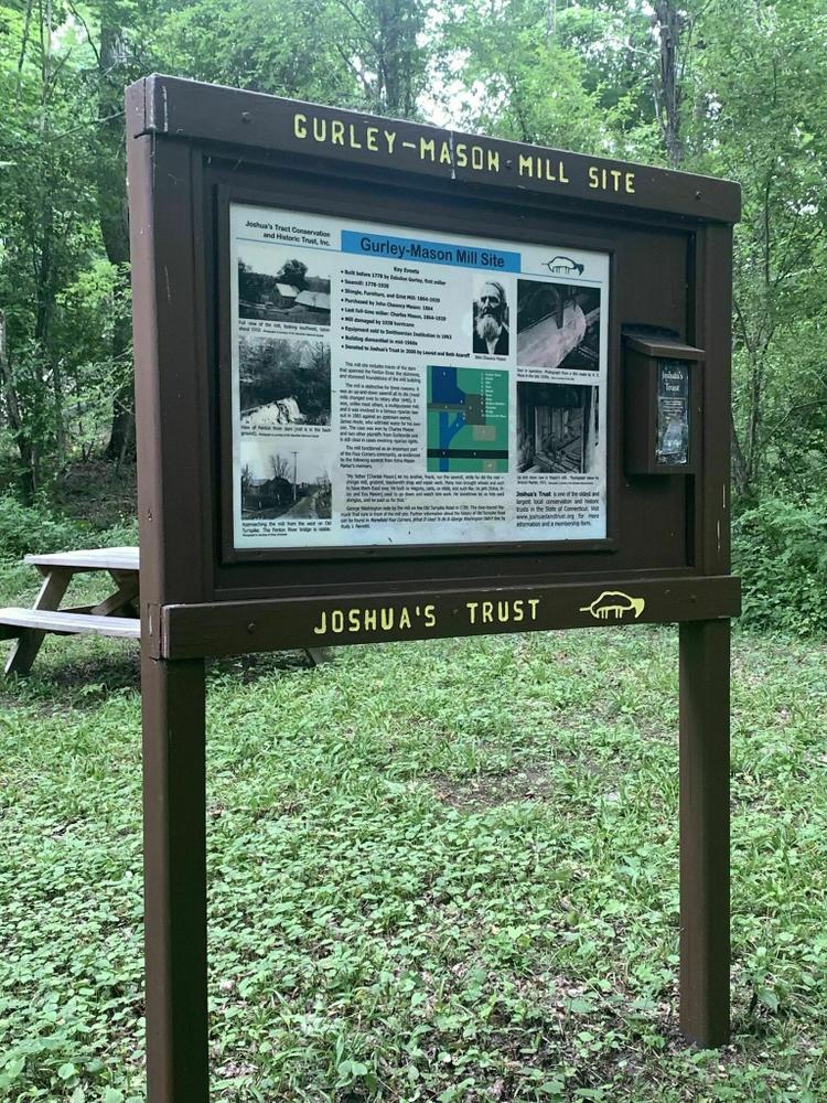
This grist and saw mill was built by Zebulon Gurley sometime prior to 1778. It is known as Mason’s Mill, named after the Mason family who acquired it in the latter half of the 19th century. It was operated as an up-and-down saw mill, and although this type of mill went out of general use in the United States around 1840, this mill continued its use until it ceased operation about 1935. The mill was torn down in the 1960’s. The saw from the mill is in the collection of the Smithsonian Institution in Washington, D.C.

In 1885, this mill was the subject of an important lawsuit over riparian rights. Charles Mason, along with Emory B. Smith and William Williams, mill owners in Gurleyville, brought suit against James Hoyle of Willington. Hoyle had dammed the Fenton River in Willington, thereby reducing the water flows for these mills operating downstream. The plaintiffs won the lawsuit that is still cited today as a precedent in cases involving water rights.

The mill functioned as an important part of the Four Corners community, as evidenced by the following excerpt from Edna Mason Parker’s memoirs.

Other Information

Rules

  • Park in designated areas only.
  • Stay on marked trails.
  • Respect other users.
  • Carry out what you carry in.
  • Do not cut or collect living plants.
  • Help protect all natural and cultural resources.
  • Keep your pet leashed.
  • No fires allowed.

Trail Manager

Joshua's Trust preserves natural habitats and heritage sites in northeastern Connecticut. To learn more contact:

Joshua's Trust
Joshua's Trust
624 Wormwood Hill Road
Mansfield Center, CT 06250
860-701-8035
View website

Trail Tips

Dispose of Waste Properly
Bury solid human waste in a cathole 6-8 inches deep and at least 200 feet from water, a campsite, or trails. Don't forget to cover it up when you're done!
Legend
Hide All

Trailhead Information

From the West

Take Route 44 east through Mansfield Depot and past the UConn campus. Bear right onto Old Turnpike Road. The site is just past the Fenton River on the left. 

From the North

Take I-84 to Willington. Head south on Route 320 until it ends at Route 195. Take a left and another quick left onto Route 44. Bear right onto Old Turnpike Road. The site is just past the Fenton River on the left. 


Click on a parking icon to get custom directions
Please Log In or Create Account to add comments.
Add a Service
Find businesses and organizations that are located around this trail that support adventuring outdoors!
Legend
Hide All
Hide All
No services shown. Try zooming out.
Hang Tight!
Nearby services are loading
SHARE THIS TRAIL
PRINT THIS TRAIL

Add Trail Log

Please wait…
Join In on the Fun!
Log in or create an account below to unlock all the great features of Connecticut Trail Finder: keep track of trails you want to do, preserve memories of trails you’ve done, and more!
Your log in attempt was not successful. Please try again.
    Lost your password? Reset your password
    Don't yet have an account?
    There was an issue with your submission. Please try again.
      * Indicates required field
      Already have an account? Login here
      Enter your username, and we will send you a new, randomly generated password to your email account.
      There was an issue with your submission. Please try again.

        Success! A new password has been emailed to you.

        Log in now

        Please wait…